
Entitlements & Land Use
Answer: Timelines vary widely but typically range from 12 to 36 months depending on location, zoning status, community engagement, and political environment. Early coordination with municipalities and stakeholders can expedite the process. Source: ULI Mixed-Use Development Handbook
Answer: Rezoning for mixed-use often involves submitting a comprehensive development plan, hosting public meetings, and negotiating with planning staff and elected officials. PUDs allow flexibility but require a clear vision and master plan. Source: American Planning Association (APA) Zoning Practice, Issue #2, 2021
Answer: Building trust through visioning workshops, market studies, and demonstration of comparable successful projects is key. Visuals and economic projections help align interests. Source: Congress for the New Urbanism (CNU) Project for Lean Urbanism
Answer: Common hurdles include outdated zoning codes, traffic impact concerns, and neighborhood opposition. These can be addressed through form-based codes, traffic calming design, and early public engagement. Source: Smart Growth America – Zoning Reform Toolkit
Answer: Typical studies include traffic impact analysis, fiscal impact reports, environmental assessments, stormwater management plans, and infrastructure feasibility studies. Source: National Association of Realtors – Mixed-Use Development Checklist
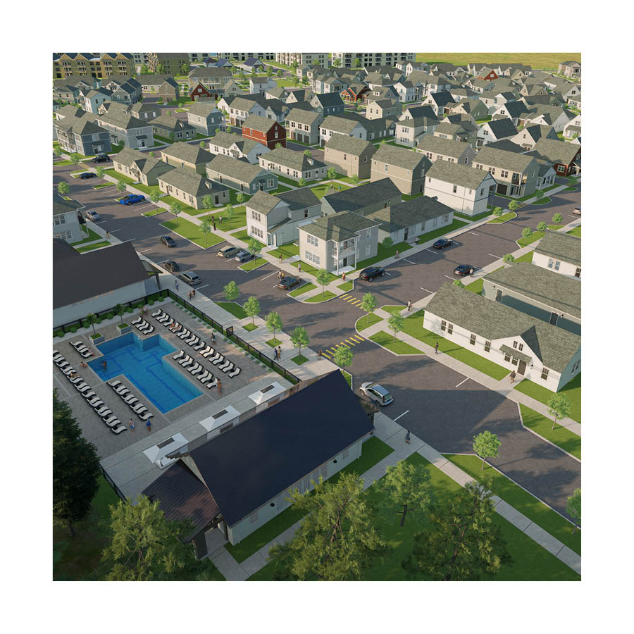
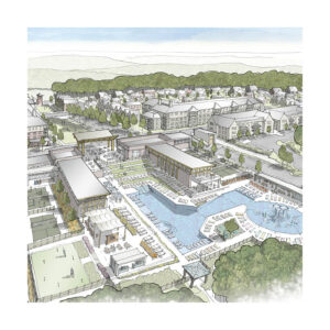
Site Planning & Land Use Strategy
Answer: Key indicators include street network connectivity, proximity to existing infrastructure, surrounding population density, and access to transit or arterials. Source: ULI Building Healthy Places Toolkit
Answer: Integrate a mix of uses within walkable distances, anchor key public spaces with civic or cultural buildings, and place active uses on the ground floor. Source: CNU Public Square Journal, “The Anatomy of Great Town Centers”
Answer: They provide health, aesthetic, and property value benefits. Open space improves marketability and contributes to environmental performance. Source: Trust for Public Land – The Economic Benefits of Parks
Phasing & Infrastructure
Answer: Begin with a catalytic phase that includes retail anchors and public space to generate momentum. Follow with residential and office components. Source: ULI Successful Public-Private Partnerships Guide
Answer: Yes, through development agreements, impact fee negotiations, and special financing districts such as Community Improvement Districts (CIDs). Source: Lincoln Institute of Land Policy – Infrastructure and Land Value Capture
Answer: Infrastructure first, followed by anchor buildings and leasing efforts. Flexibility in phasing based on market demand is important. Source: CNU Charter Awards Case Studies
Answer: Establish a strong form-based code or design guideline early, maintain a cohesive materials palette, and protect key civic elements. Source: Form-Based Codes Institute
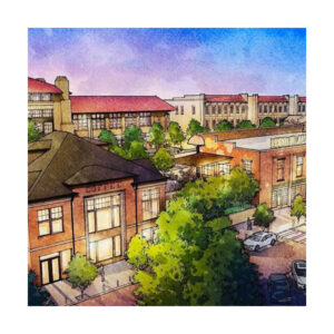
Walkability & Street Design
Answer: Prioritize pedestrians with narrow lanes, wide sidewalks, shade trees, on-street parking, and traffic calming measures. Source: National Association of City Transportation Officials (NACTO) Urban Street Design Guide
Answer: Main streets should be 2-3 lanes wide with parallel parking, street trees, and active ground floor uses. Rear service alleys enhance functionality. Source: CNU and NACTO Design Manuals
Answer: Yes. Streets designed for 20-25 mph reduce crash severity, encourage walking, and create a more vibrant street life. Source: USDOT and Smart Growth America, “Dangerous by Design”
Answer: Shared streets are ideal for low-speed, high-activity zones such as plazas and market streets. They encourage interaction and flexible use. Source: NACTO Urban Street Design Guide
Parking & Mobility
Answer: Shared parking, reduced ratios (0.6–0.8 per unit), and alternative mobility options often reduce demand significantly. Source: ULI Shared Parking Report (3rd Edition)
Answer: Yes, by accommodating complementary uses (e.g., office day, residential night), developers can reduce paved surface and construction costs. Source: Institute for Transportation Engineers (ITE)
Answer: Parking decks wrapped with liner buildings preserve active frontage, while alleys allow for hidden service access and rear parking. Source: CNU Project Database
Answer: Advocate for reductions, use parking demand studies, and promote code flexibility such as shared use, valet, or payment in lieu. Source: Strong Towns Parking Reform Network
Cost, Revenue & Incentives
Answer: New Urbanist developments can reduce infrastructure costs by ~38% through compact design and shared infrastructure. Source: Smart Growth America – Building Better Budgets Report
Answer: TIF can fund infrastructure upfront and repay costs from increased future tax revenues. PPPs bring public investment into shared benefits. Source: Brookings Institution PPP Case Studies
Answer: Town centers can generate 10x more tax revenue per acre than traditional big-box or strip centers. Source: Joe Minicozzi / Urban3 Fiscal Analysis
Answer: Yes. Homes in walkable areas command up to a 20% premium, and retail spaces in walkable districts have higher rents and lower vacancies. Source: George Washington University / Smart Growth America WalkUPs Report
Marketability & Community Impact
Answer: Studies show 12–20% higher home values and faster sales in well-designed walkable communities. Source: RCLCO / CNU Market Trends Report
Answer: Public space design and pedestrian connectivity increase social capital and spontaneous interaction. Source: Project for Public Spaces (PPS)
Answer: Higher per-acre tax yield, better infrastructure ROI, lower service costs, and more resilient local economies. Source: Strong Towns, Urban3 Fiscal Analysis
Answer: Increased street activity, natural surveillance, and resident presence often correlate with reduced crime. Source: Journal of Planning Literature, “Crime and Urban Form”
Sustainability & Environmental Impact
Answer: Compact, mixed-use neighborhoods reduce driving, increase walking/transit use, and require less energy for infrastructure. Source: EPA Smart Growth & Climate Change Report
Answer: VMT can be reduced by up to 40% in walkable communities vs conventional suburban development. Source: Transportation Research Board – Land Use and Travel Behavior Study
Answer: Higher density means fewer acres consumed per household, leaving more land for nature, agriculture, or recreation. Source: American Farmland Trust
Working with Municipalities
Answer: Tax revenue, job creation, quality public space, housing choice, and a strong identity. Source: National League of Cities – Economic Development Tools Guide
Answer: Use comprehensive plans, master plans, zoning language, and community goals as references. Emphasize fiscal return and placemaking. Source: ICMA and APA Planning Communication Guide
Answer: Focusing solely on ROI, not addressing community benefits, ignoring visuals, and failing to engage early with stakeholders. Source: ULI Developer Outreach Best Practices
Common Challenges
Answer: Town center developments often fail due to a lack of clear vision and leadership, weak early-phase anchors (like retail or public space), poor phasing, and underestimating the complexity of managing multiple uses. Failure to engage the community or address local context also contributes. Source: ULI Mixed-Use Development Handbook; CNU Public Square “Lessons from Failed Urban Projects”
Answer: Use market-aligned phasing strategies, begin with catalytic uses that create momentum, and maintain consistent design standards. Establishing design codes, securing early public/private partnerships, and being flexible in use mix helps mitigate risk. Source: RCLCO Development Risk Management Report; ULI Ten Principles for Building Resilient Communities
Answer: Early delivery of well-designed public space, placemaking events, lifestyle renderings, and strong branding help build momentum. Early commitments from anchor tenants or civic uses (like libraries or food halls) signal long-term value. Source: PlacemakingX Activation Guide; ULI Building Healthy Places Toolkit
Answer: Start with a market analysis to determine viable demand. Design to support complementary uses (e.g., residential foot traffic for retail, civic spaces that draw office workers) and phase uses to build energy over time. Source: ULI Mixed-Use Development Handbook; RCLCO Mixed-Use Strategy White Paper
Answer: Focus on experiential retail (food, wellness, services, events), support local and regional tenants, and create unique destinations with a sense of place. Blend retail with programming and civic events to maintain relevance. Source: ICSC “Future of Retail”; ULI “Retail in the Mixed-Use Environment”
Why Work with Us?
Answer: We integrate community input early, align designs with comprehensive plans, and produce highly visual presentations that communicate value to planners and elected officials. Our deep experience with zoning reform and form-based codes streamlines approvals. Source: Firm Case Studies; APA Zoning Practice Reports
Answer: Our projects emphasize timeless design, public realm quality, and community identity—key factors in faster home sales and stable commercial leases. We also integrate flexible space planning for evolving market needs. Source: RCLCO Placemaking Report; CNU “Why Design Matters”
Answer: Yes. We offer integrated branding, storytelling, stakeholder engagement, and public meeting support to ensure alignment across audiences. Our goal is to help developers clearly articulate the project’s value. Source: Firm Portfolio; ULI Guide to Public Engagement for Developers
Answer: We blend engineering standards, municipal goals, and market realities into street designs that enhance value, safety, and community identity. Our block structures support flexibility, phased growth, and placemaking. Source: NACTO Street Design Guide; Form-Based Codes Institute
Answer: We use fiscal analysis tools (e.g., Urban3), data on absorption and premiums from comparable projects, and visualizations to communicate how good design increases tax yield, lowers crime, and boosts long-term ROI. Source: Urban3 Fiscal Impact Models; Smart Growth America – The Value of Design